
Sometime in May, a building along the Gowanus Canal in Brooklyn was burning. A hazy white billowing cloud set against the bright blue sky rose up over a warehouse building near 8th Street. It seemed innocuous at first, like some rogue exhaust from one of the dozens of manufacturing facilities in the area – until sirens blaring from a distance made their way into the fray. The faint smell of something like burning tar, a smell all too familiar along this stretch, filled the air. Eventually those puffy white clouds gathered into something more menacing; a dark heap of soot slowly rose over a building by Dyke’s Lumber and a crowd gathered at the canal overpass to watch. Like others in the crowd I was initially drawn to the edge of this tiny bridge to watch the fire unfold, but the crowd and I quickly turned our attention to the canal just about ten feet below our feet. “I was walking down 6th and the whole time I just thought the smell was coming from the canal,” says one guy. People nod in agreement. A few others start playing “I spy…” – a scavenger hunt of sorts. There’s a decades old computer, a fishing net, and a bike wheel half-floating in the dense swampy water while further in the distance air bubbles burst at the surface amid the cloudy rainbow film of oil. And all I could think was “what could possibly live down there….”

Even though I had passed by the Gowanus Canal many times on my way through Carrol Gardens or Park Slope I still had no real idea of what this slice through Brooklyn actually was. Here’s one of the reasons why: you can never really see or occupy the edges of the canal. It only becomes visible from one of the short bridge crossings. Unless you happen to be in the yard of one of the manufacturing or industrial buildings it is hard to catch a glimpse. The canal is confined to the interior lots, hidden from view in many cases. Even longtime residents are unfamiliar with its existence – much less its origins (was it a natural waterway or man-made?) – cannot discern its truth from myth (is this really a dumping ground for the mafia?) and are unclear on its purpose (what’s with all the draw bridges and fog lights?) or safety (does gonorrhea really thrive in its waters?).
But if you are one of the people familiar with the Gowanus Canal you know that the sight of it today is disturbing, with its floating refuse, polluted water and profuse smell. My first impressions of this seemingly insignificant waterway through Brooklyn was that it was a relic of the city’s industrial past, neglected in the past century. Some natural fresh water channel confined by the city’s expansion of concrete and asphalt that had long been forgotten. This was not completely far from the truth, but I wanted to know more so I decided to do a little bit of research on this natural-unnatural part of the city.

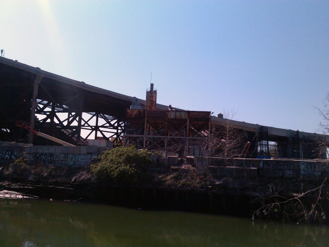
It turns out that the Gowanus Canal has had a long and intertwined history with the development of New York and Brooklyn in particular but you wouldn’t be able to guess this based on the state of the canal today. This often overlooked body of water that cuts a two-mile path from the Gowanus Bay into some of the most prosperous neighborhoods of Brooklyn was recently declared a Superfund site and has since undergone thorough ecological investigation to determine the extent of its environmental damage. Over the years the canal has gained notoriety for its foul stench and for the collection of debris that gathers along its shallow shores. It has even made its way into pop culture and myth where it is considered a cesspool of disease and the dumping grounds for the mafia. For locals the myth of the canal surpasses its truth. So much so that it has been neglected all of these years.
Despite its appearance, there’s an inherent beauty in this seemingly quaint stretch of water that juts into Brooklyn and it tells a story of the delicate balance of the creek’s health, an example of so much of NYC’s natural landscape, usurped by industry. Like many people living in Brooklyn faintly aware of this canal, I thought it had long gone out of use. Yet the few times that I have stood along its shores I have witnessed some activity: the drawbridges still operate for fire boats that navigate along it and the barges that occasionally float by make a fuss with fog lights, bells and whistles – a light indication of its once prosperous industrial uses. More than that, it now serves the city as an open sewer into which storm water and sewage overflow passes through on its way into the bay. In other words this body of water is an intricate part of New York City’s sewer system. It is one of the reasons why our streets don’t overflow with sewage every time it rains. It’s called a Combined Sewage Overflow (CSO) and it is one of many throughout the city that is part of an overburdened and outdated sewage management system. But more on that later because even that unpleasant circumstance doesn’t fully explain why the US Environmental Protection Agency has declared it a Superfund site.
If we take a few steps back to NYC’s origins as New Amsterdam we have to give the city’s intricate waterways a lot of thought. They helped make the city as economically and politically significant as it is today. I grew up in New York City, in the only borough that isn’t technically on an island and I never associated the city with its vast and interconnected waterways. And yet I lived just a few miles from the Bronx River, which also happens to be one of those polluted industrial waterways that winds its way down into the bay. I traveled into Manhattan often and through it into Brooklyn underground on the subway hardly considering the engineering of the tunnels that dissipated that intricate distinction between the boroughs. It’s a fascinating disconnect considering how vital the geography of New Amsterdam was to its establishment and early development as a port city of priority. It’s simply that in New York City, water is no longer the obstacle it once was, nor is it its only transportation and trade.
So let’s remember: we are stranded on an island and scattered around its periphery. We are surrounded by water and divided by it. Yet we’ve stifled this natural element so successfully that many of us completely forget that it exists. Our rivers are straddled by bridges and penetrated by tunnels. We can navigate this city without ever thinking about the proximity of water and we are shocked when it turns on us. We can plunge underground into the bedrock, into the slithering subways and emerge along its outer banks without the slightest consideration of having just been buried below a river. That’s how easy it is to forget and neglect all of it.
But long ago, the Gowanus Canal was one of those significant waterways that helped make Brooklyn a prosperous port city that saw tremendous development alongside Manhattan in the early 20th century. It was once pivotal to the economic and social development of Brooklyn and has since been withered down in its perception to a “toxic waste site and open sewer”. The decline of the Gowanus Canal is just another version of a well-known story in our history; it is a combination of the state of a post-industrial city and its outdated infrastructure. One writer, Joseph Alexiou, is determined to uncover the truth about the canal and bring its history to light. Alexiou lectured to a full room at the Brooklyn Brainery – an adult learning center in Brooklyn Heights – explaining the long history of the canal and covering the subject of its potential future from research gathered for a forthcoming book on the subject.
He was one of the resources that helped me draft a much more sober picture of the extent of the damage within this artifact of Brooklyn’s history. Thanks to the Brooklyn Brainery, Joseph Alexiou, and the EPA’s detailed report on the Gowanus Canal the story is coming together: One of my first questions about the canal was whether it is man-made or naturally occurring? And the answer, of course, is much more complicated than either/or in that it is both.
What is known today as the Gowanus Canal started out as the Gowanus Creek, a natural salt-water tidal marsh that flooded and drained naturally. Red Hook, Gowanus, Carroll Gardens, Park Slope and Cobble Hill now comprise what was once the banks of the undefined marsh which provided a lush habitat for salt-water grasses and a natural defense for the burgeoning city within central Brooklyn in the early 19th century. Looking at today’s map of the canal probably makes this inconceivable. The hard-line boundaries drawn by the bulkheads of the canal looks like anything but natural. Today it is a 1.8-mile long, 100-foot wide channel defined by concrete, logs and steel with several basins that jut out into the various neighborhoods along its course and serve additional docks and turn-around points along its route.

This transition happened in the mid-19th century when the land of the lush marsh was considered too valuable to leave uninhabited. Thus began the plan to fill the marsh with sturdy soil to prevent future flooding and create solid ground on which to build. Around the same time, the city became acutely aware of its own sanitation problem: Brooklyn was expanding rapidly and began suffering from sewage management issues. The existing sewer system could no longer handle the flow that the city produced, particularly during heavy rains when it flooded the streets with raw, untreated sewage. To solve this problem the city developed the Combined Sewage Overflow system (CSO) which would divert excess sewage that treatment plants could no longer handle into the closest open waterways that fed into the outer bays. The Gowanus Creek was one such available waterway and to provide the solution for the two pressing issues facing the city, the Gowanus Canal came into being. The creek was promptly confined to its present-day bulkheads, creating a hard edge to the once amorphous marsh. The land surrounding the canal was filled in until the marsh was completely buried allowing new development to occur and the contained waterway would serve as the CSO solution to the surrounding neighborhoods.
So began the industrial era of the canal. The land along the canal was perfect for manufacturing and industrial uses. Its proximity to New York Harbor made it an ideal commercial route. Thus, by the early 20th century manufacturing plants started popping up along the banks of the canal which now served a direct connection between New York Harbor and the markets of Brooklyn steadily growing to prominence alongside Manhattan. The industries that sprang up were varied and included manufacturing gas plants (MPGs), coal yards, cement manufacturers, tanneries, paint and ink factories, machine shops, chemical plants and oil refineries. By 1922 these manufacturing and commercial uses brought in as much as $100 million from just the Gowanus Canal. The waterway was inarguably a major asset to Brooklyn’s economic growth.
Throughout this period lax environmental laws allowed for discharge from these various industries to be flushed directly into the waterway, poisoning the salt water with a garden variety of chemicals including PAH, PCB, heavy metals, BTEX, NAPL and VOCs all of which are hazardous substances, and in some cases proven carcinogens, that mixed with the raw sewage entering the canal. Eventually, the Gowanus Canal dropped off as a main source of income when trucks and container shipping began to replace barge shipping in the mid-20th century. Robert Moses’ urban planning agendas provided the city with its mass network of highways. The Brooklyn Queens Expressway gained prominence as a shipping route and for the most part industry left the Gowanus. But throughout those decades that the canal was functioning as the main trade and transportation route for industrial goods, about 10-feet of sludge accumulated along the canal bed. The EPA conducted extensive tests on the toxicity of the water, testing for carcinogens upon contact and ingestion. The rumors about gonorrhea and cholera residing in these waters is not far from the truth and direct contact with the water is highly discouraged.
The toxic dumping may have ceased, but the result of decades of ecological abuse is for us to sort out. In addition to the canal still maintains its CSO functions. Raw sewage floods the canal during heavy rains, as this video demonstrates. During Hurricane Sandy there were reports of nearby apartments flooded by overflowing toilets and sinks with the sewage from the canal. Yet this toxic site and its present-day malfunctions still has an elusive existence in Brooklyn’s current narrative. Shortly after the EPA declared the Gowanus Canal as a Superfund site in 2010 the agency released a proposed remedial plan that would cost an exorbitant $506 million for the city and private companies. The process outlined by the EPA offers a variety of solutions but the highest recommended plan includes dredging the sludge that rests at the bottom of the canal and creating a secondary solution to the CSO, such as building retention tanks that store raw sewage until it can be directed to the sewer system for treatment plants to safely handle it.

In late September of 2013 the EPA announced a final plan, citing responsible parties, and provided a timeline for the canal’s clean up, a survey of work that includes dredging and stabilizing the toxic sediment at the bottom of the canal. The Gowanus Canal Community Advisory Group (CAG), established in 2010, has aligned itself with the EPA to promote this plan with input from the community, and arriving at a consensus for clean up techniques and ecological renewal.
The Record of Decision, as the final drafted plan is called, promises to bring new opportunities for urban engagement in the post-industrial landscape. Possibly even finding a way back into its natural state.
